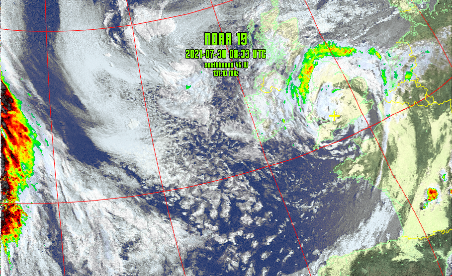
Decoding images from APT weather satellites

Overview
Can I decode weather imagery on my home made antenna?
Weather Satellites
There are a lot of satellites orbiting Earth, some are communication satellites, some are imagery satellites, and some of those imagery satellites produce images that an amateur can capture and decode.
There are a number of NOAA satellites that transmit pictures in a format called Automatic Picture Transmission (APT). Specifically, there are three satellites:
- NOAA-15 - downlink on 137.620 MHz
- NOAA-18 - downlink on 137.9125 MHz
- NOAA-19 - downlink on 137.100 MHz
Kit
The kit list is pretty similar to that for capturing SSTV from ISS, but I did make a QFH Antenna tuned to 137 MHz to improve reception
| Serial | Category | Item | Notes |
|---|---|---|---|
| 001 | Antenna | Home made QFH antenna | Vertically mounted in a tree in the back garden |
| 002 | Coax run | 5m of RG58 terminated in a SMA-M | |
| 003 | Radio hardware | SDRPlay RSP-1A | |
| 004 | Radio software | SDR Console | Includes satellite tracking capability and doppler compensation |
| 005 | APT decoding software | WXtoIMG |
A straightforward setup reusing a lot of what I'd learned / used for ISS SSTV capture. Again, using a Virtual Audio Cable to pipe the received audio from SDR Console to the APT decoding software.
Operation
There are a number of steps that I followed:
- Identify a good satellite pass
- Set up the SDR (including I/Q recording) and pipe the audio via the VAC
- Set up WXtoIMG to receive audio via VAC
- Capture I/Q and audio signal during satellite pass as a backup
- Allow WXtoIMG to decode pictures
So let's look at each step in turn.
Identify a good satellite pass
As with ISS, higher elevation passes tend to be longer and have a better signal, but there is some advantage to lower angle passes. The satellite images the ground beneath it so a pass to the West of you covers different geography to a pass overhead or to the East, so some of the lower passes are worthwhile capturing but obviously signal strength can be an issue.
Set up the SDR
APT signals are FM modulated and quite wide, so W-FM mode is selected and I let the satellite plug-in for SDR Console manage the doppler compensation and recording. All I need to do is set up the radio with 500kHz as the bandwidth and ensure that Doppler compensation and recording is turned on, and that the SDR is outputting to the VAC.
Set up WXtoIMG
WXtoIMG has a LOT of settings, I'm not going to write a tutorial on using it, there is a manual online and lots of other great write ups on how to use it. Instead, I'll just note any specific settings I've used.
The primary thing to set is the soundcard input, in this case, my virtual audio cable. Otherwise WXtoIMG will run automagically and decode the audio when it is fed to it.
I adjusted the auto process options to produce the visualisations that I wanted, and also set up the priority of satellites when there were multiple satellites visible at once.
Capture I/Q and audio signals during satellite pass as a backup
The basic process is to sit and wait and let it all happen. However, I've seen a number of issues that can be resolved with a recording of the audio from the pass. SDR Console lets you record the I/Q or just the audio. The audio recording takes the doppler correction into account, so I usually just record the audio now.
Allow WXtoIMG to decode pictures
With any luck, WXtoIMG will just work and you get all the images you wanted. If not, then it is possible to salvage something if you have recorded the audio. Typically, the issue is that WXtoIMG didn't sync properly and in this case you can 'wash' the audio file through another piece of software called noaa-apt, this has a feature to decode the audio and display the image, as well as matching the timestamp of the WXtoIMG audio file so you can swap them over and process your recording.